
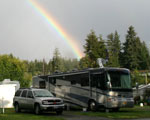

6/14/06 - Bluff, UT
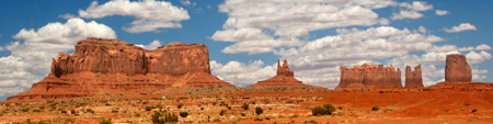
Wednesday we drove to Bluff, Utah (Map)through Monument Valley and Mexican Hat. It was very windy and there was a sand storm in the Monument Valley area, so we did not stop, except very briefy to take a couple of photos from the road. I must admit the photo above has been altered to incude the sky of a much more beautiful day. We pulled into a nice little RV Park called Cadillac Ranch and enjoyed the next several days there.
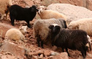 Wild Sheep near Bluff, UT |
The next day we drove around Bluff and discovered an old Indian ruins which is being excavated. We also stopped at the Navajo Twins  which has a gift shop with a wonderful collection of Indian art, including a large basket collection, and a restaurant where I had a huge Indian Fry Bread taco meal. We stopped to take some photos of this herd of wild sheep and enjoyed the red rock formations near Bluff too.
Later that day I took Tara for a walk around Bluff and we explored the Bluff Fort Historic Site which has a couple of old log buildings and other artifacts. We then walked over to the Navajo Twins from a different approach and took this photo.
6/16/06 - Natural Bridges and Valley of the Gods
The next day I took Tara for a long drive, while my wife stayed home and did some decorative painting. We headed north on 163 and then turned west on 95. I had read about an old Indian watch tower and stopped where I thought it might be and took Tara for a fairly long hike in search of it. Unfortunately we only found lots of rocks, twisted old Junipers and Pinyon Pines .
Then we stopped at a very well marked Indian ruins that was nearby. As we continued west, we passed by some cattle in an open range that thrilled Tara.
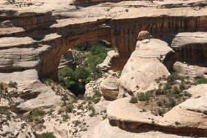 Sipapu Bridge |
Our next stop was at Natural Bridges National Monument. There is a fairly short loop road through the park which had recently been repaved and everything was very neat and clean. We stopped at the Sipapu Bridge and ate a sandwich I had brought for lunch. Then we continued on to the Kachina Bridge , stopping a few times to take in the beautiful rock formations.
The hike down to the Kachina Bridge is fairly long and steep, so I decided not to get a closer look and drove on to the Owachomo Bridge. Here the hike is much easier, so we descended the .25 mile trail down to the canyon floor and this beautiful natural bridge.
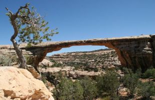 Owachomo Bridge |
The Owachomo Bridge is nearly 200 feet across and over 100 feet high. The hike down was very beautiful and I loved this huge split boulder we found near one end of the bridge.
Next we headed back East and then turned South on 261 towards Mexican Hat. About half way we encountered an area known as the Mokee Dugway. This is a three mile dirt section of road that winds from 6425 feet down to 5325 feet. The view of the Valley of the Gods from the top was spectacular.
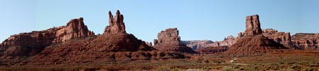
Sometimes called the "other Monument Valley" the lessor known Valley of the Gods is nearly as wonderful. A 17 mile drive winds around many of the tall rock spires and cliffs in the area. I thoroughly enjoyed my drive and a few short walks in this sacred valley.
Then we drove down to Mexican Hat and drove down some dirt roads to witness this remarkable natural wonder. I was also impressed with red rock formations and the San Juan River that flows nearby.
6/18/06 - Capitol Reef
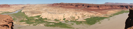
Saturday we moved to Torrey, UT (Map) which is near Capitol Reef. On the way we stopped in Hite, UT on the Colorado River, where we thought we would find a place to eat, but all we found was a gas station and a boat ramp. Apparently this once was a booming little town, but when they built the dam, most of it wound up under the new lake. We had a nice lunch in our coach instead.
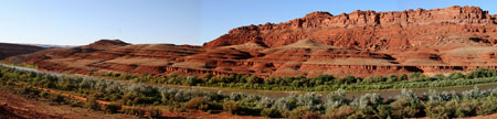
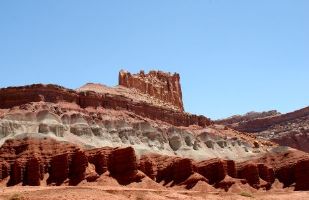 Capitol Reef National Park |
It was a beautiful drive and we passed through part of the Capitol Reef National Park to get to Torrey which is nearby. We camped at Wonderland RV Park for a couple of nights, which was very nice.
On Sunday we drove into Capitol Reef and were awed by the rock formations there. I especially loved this rock that looked like some kind of monster .
I was also particularly impressed with Capitol Gorge but the entire trip was very beautiful and interesting.
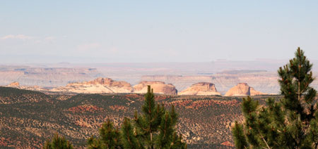
After we left the park we decided to go for a drive up Boulder Mtn. to see the park from the high mountains to the West. Most of the drive was very forested, but we stopped at a couple of view points and took photos. We also stopped in a big meadow and let the dogs run for awhile.
That evening we had dinner at a wonderful restaurant called Cafe Diablo in Torrey. The have a great menu which includes Rattlesnake cakes, Lamb, Salmon, Ribs, Chicken, Beef and even Lobster. The presentation was beautiful, the service extraordinary and the food delicious. They have a great dessert menu too.
|
This software runs on Windows 10 & 11 and Mac OS 10.2 to 10.14 |


|
PhotosByGarth is a division of SpiritWorks Software Inc. |