


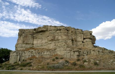
Photo © 2006, Garth Catterall-Heart Pompey's Pillar, MontanaPompeys Pillar National Monument is located in south central Montana, United States. Designated a National Monument on January 17, 2001 and managed by the U.S. Bureau of Land Management, it consists of only 51 acres (206,000 m2), making it the smallest National Monument in the U.S. The pillar itself stands 100 feet (30 m) above the Yellowstone River and consists of sandstone from the late Cretaceous Hell Creek Formation, 75-65 mya. The base of the pillar is approximately 1 acre (4,000 m2). The primary reason for the pillars designation as a national monument is due to the abundance of Native American petroglyphs and the signature of William Clark of the Lewis and Clark Expedition. Clark's inscription is the only remaining physical evidence found along the route that was followed by the expedition. The inscription consists of his signature and the date July 25, 1806. Clark claimed he climbed the sandstone pillar and "had a most extensive view in every direction on the Northerly Side of the river". The pillar was named by Clark after the son of Sacagawea who was the Shoshone woman who had helped to guide the expedition and had acted as an interpreter. Clark had called Sacagawea's son "Pompy" and his original name for the outcropping was "Pompys Tower". It was later changed (1814) to the current title. Situated 25 miles (40 km) northeast of Billings, Montana, along Interstate 94 the pillar gets 50,000 visitors annually. Archeological evidence suggests that the outcropping has been witness to 11,000 years of human involvement in the area. Consequently, in addition to the pictographs and the signature of William Clark, hundreds of other people have carved their initials into the rock, including early pioneers to the area. From Wikipedia, the free encyclopedia Photo ID = 050909_266c_1632 Keywords = Pompey's Pillar, Montana Horizontal or Landscape Prints at special prices. This photo may be available in other sizes. |
Pick a quotation to add to this photo for only $25 extra
Order a 5x7 print |
Order a 8x10 print |
Order a 11x14 print |
Order a 5x7 print |
Order a 8x10 print |
Order a 11x14 print |
Order a 5x7 print |
Order a 8x10 print |
Order a 11x14 print |
Have a 900x1392 |
Have a 1440x1800 |
Have a 1980x3060 |
| Other photos taken at the same time as this photo. | |||
|
|
|
|
|
PhotosByGarth is a division of SpiritWorks Software Inc. |